The World’s Strongest Tropical Cyclone ‘Yolanda’

CNN call it the World’s Strongest Typhoon in 2013 stronger than Category 5 Hurricane Katrina, “Yolanda” (International Name: Haiyan) has made fifth landfall over Concepcion, Iloilo. At 1 pm, Typhoon “YOLANDA” was at the vicinity of Cuartero, Capiz, with maximum sustained winds of 200 kph and gustiness up to 230 kph. Forecast to move West Northwest at 40 kph.perfect circle haiyanperfect circle haiyan 2

Check out the Public Storm Warning Signals issued by PAGASA.

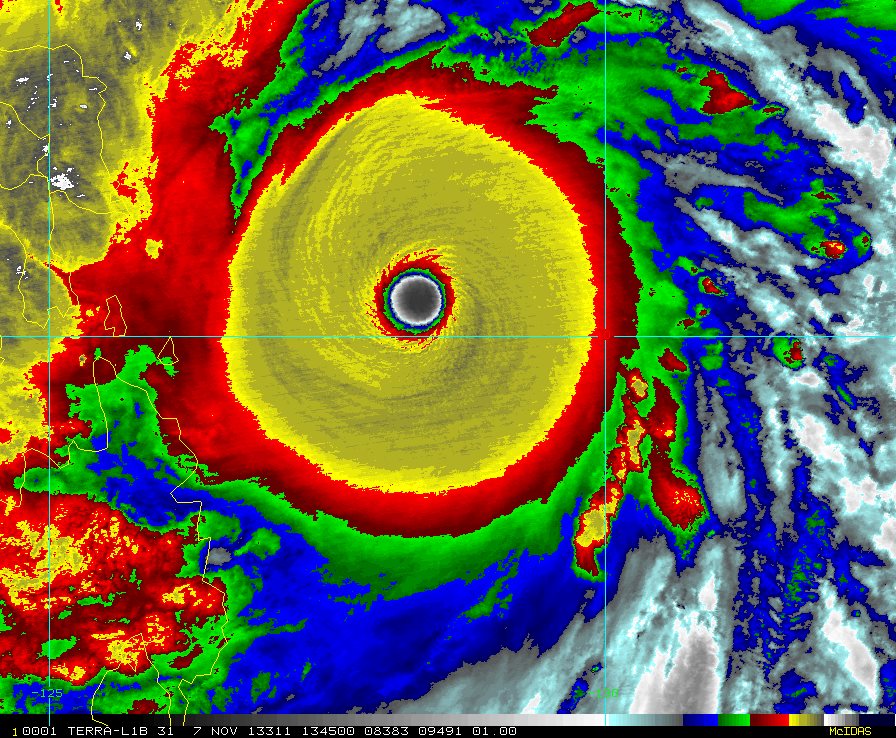
Areas Having Public Storm Warning Signal
PSWS # Luzon Visayas Mindanao
Signal No. 4
( >185 kph winds may be expected in at least 12 hours)
Southern Occidental Mindoro
Southern Oriental Mindoro
Romblon
Calamian Group of Island
Masbate
Northern Cebu
Cebu City
Bantayan Island
Northern Negros Occidental
Aklan
Capiz
Antique
Iloilo
Guimaras
None
Signal No.3
(Winds of >100 to 185 kph may be expected in at least 18 hours)
Rest of Occidental Mindoro
Rest of Oriental Mindoro
Burias Island
Sorsogon
Marinduque
Ticao Island
Northern Palawan
Puerto Princesa City
Northern Samar
Eastern Samar
Samar
Leyte
Southern Leyte
Bohol
Rest of Cebu
Negros Oriental
Rest of Negros Occidental
Camotes Island
Biliran Province
Dinagat Province
Signal No. 2
(winds of >60 to 100 kph may be expected in at least 24 hours)
Bataan
Metro Manila
Rizal
Cavite
Laguna
Batangas
Southern Quezon
Camarines Sur
Lubang Island
Rest of Palawan
Albay
Siquijor Surigao del Norte
Siargao
Camiguin
Signal No. 1
(30-60 kph winds may be expected in at least 36 hours)
Pampanga
Zambales
Bulacan
Camarines Norte
Rest of Quezon
Polilio Island
Catanduanes
None Surigao del Sur
Misamis Oriental
Agusan del Norte
Public Warning Signal #1 elsewhere are now lowered.“YOLANDA”, after hitting Guiuan ( Eastern Samar) and Tolosa, Leyte, is now in the vicinity of Northern tip of Cebu and will traverse Visayan Sea and will hit Panay Island between 12:00 noon to 1:00 pm then will pass in the Southern part of Mindoro then Busuanga and will exit the Philippine landmass this evening towards the West Philippine Sea.Estimated rainfall amount is from 10.0 – 20.0 mm per hour (Heavy – Intense) within the 400 km diameter out of 600 km diameter of the Typhoon.Sea travel is risky over the seaboards of Northern Luzon and over the eastern seaboard of Central Luzon.Residents in low lying and mountainous areas under signal #4, #3 and #2 are alerted against possible flashfloods and landslides. Likewise, those living in coastal areas under the aforementioned signal #4, #3 and #2 are alerted against storm surges which may reach up to 7-meter wave height.

 Check out more updates from PAGASA Official Website

In a nationwide telecast from Malacanang, Philippine President Noynoy Aquino alerts citizens on the impending damage of Super Typhoon Yolands earlier with center winds of 225 kph and gustiness of up to 260KPH.

Among the Strongest and Perfect Circle Cyclone: Haiyan